NC4K_22_03
- Distance: 316.2 Km
- Elevation gain: 1,975 m
- Maximum elevation: 725 m
- Elevation loss: 2,627 m
- Minimum elevation: 33 m
Interactive map
GPS track profile
About this GPS track
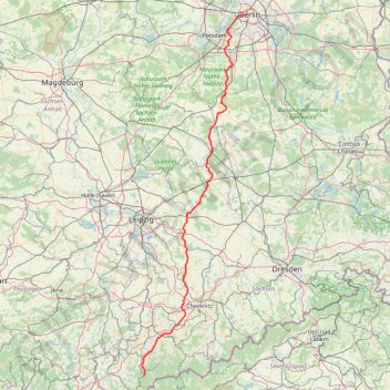
Name: NC4K_22_03 GPS track, route, trail
End: Pariser Platz, Dorotheenstadt, Mitte, Berlin, 10117, Allemagne (52.51613 13.37803)
Coordinates: 50.41675 12.38373 52.51617 13.37803
Other GPS tracks
Click on a GPS track to view route, its statistics and profile.
Tour d'Europe
France > Bretagne > Finistère > Concarneau > Landan Creis
Distance: 7,132.9 Km • Elevation gain: 44,603 m • Maximum elevation: 2,433 m
Marche-en-Famenne
Belgique > Luxembourg > Marche-en-Famenne > Marche-en-Famenne
<p>From Rue Dupont 46, 6900 Marche-en-Famenne, Belgium<br/> To Avenue de France, 6900 Marche-en-Famenne, Belgium</p> <p>Routing Motor - nicest</p>
Distance: 2,843.5 Km • Elevation gain: 28,856 m • Maximum elevation: 1,078 m
Biking#4
Germany > Saxony > Mittelsachsen > Augustusburg > Erdmannsdorf
Distance: 13.0 Km • Elevation gain: 247 m • Maximum elevation: 467 m
Görlitz - Alpen
Germany > Saxony > Görlitz > Görlitz
Distance: 749.5 Km • Elevation gain: 5,160 m • Maximum elevation: 446 m
Görlitz - Alpen
Germany > Saxony > Görlitz > Görlitz
Distance: 749.5 Km • Elevation gain: 5,160 m • Maximum elevation: 446 m