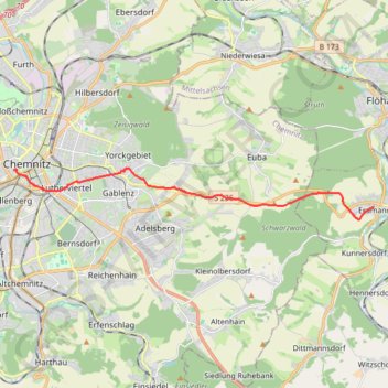
Biking#4
- Distance: 13.0 Km
- Elevation gain: 247 m
- Maximum elevation: 467 m
- Elevation loss: 248 m
- Minimum elevation: 300 m
- Moving time: 42 m 2 s
- Moving speed: 18.6 Km/h
- Maximum speed: 55.4 Km/h
- Total time: 42 m 2 s
- Global speed: 18.6 Km/h
- Date: 19/09/21
Interactive map
GPS track profile
About this GPS track
Name: Biking#4 GPS track, route, trail
End: 8, Hohe Straße, Kaßberg, Chemnitz, Saxony, 09112, Germany (50.83061 12.91345)
Coordinates: 50.81640 12.91345 50.83099 13.07477
Topography: Mittelsachsen topographic map
Other GPS tracks
Click on a GPS track to view route, its statistics and profile.
Tour d'Europe
France > Bretagne > Finistère > Concarneau > Landan Creis
Distance: 7,132.9 Km • Elevation gain: 44,603 m • Maximum elevation: 2,433 m
Marche-en-Famenne
Belgique > Luxembourg > Marche-en-Famenne > Marche-en-Famenne
<p>From Rue Dupont 46, 6900 Marche-en-Famenne, Belgium<br/> To Avenue de France, 6900 Marche-en-Famenne, Belgium</p> <p>Routing Motor - nicest</p>
Distance: 2,843.5 Km • Elevation gain: 28,856 m • Maximum elevation: 1,078 m
NC4K_22_03
Allemagne > Saxe > Vogtlandkreis > Muldenberg
Distance: 316.2 Km • Elevation gain: 1,975 m • Maximum elevation: 725 m