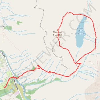
Meall an t-Suidhe and Lochan Meall an t-Suidhe Loop
Loop hike from Glen Nevis to Meall an t-Suidhe and Lochan Meall an t-Suidhe via Ben Nevis Mountain Path. #Hike #Loop #Nature #Forest #Mountain #Lake
- Distance: 9.2 Km
- Elevation gain: 757 m
- Maximum elevation: 704 m
- Elevation loss: 757 m
- Minimum elevation: 21 m
- Moving time: 3 h 50 m
- Moving speed: 2.4 Km/h
- Maximum speed: 5.3 Km/h
- Total time: 4 h 46 m
- Global speed: 1.9 Km/h
- Date: 11/02/24
Interactive map
GPS track profile
About this GPS track
Name: Meall an t-Suidhe and Lochan Meall an t-Suidhe Loop GPS track, route, trail
Coordinates: 56.79799 -5.07144 56.81376 -5.03595
Other GPS tracks
Click on a GPS track to view route, its statistics and profile.
Ben Nevis by the Mountain Path
Royaume-Uni > Écosse > Highland > Glen Nevis > Achintee
GPX file from Walkhighlands; file is copyright Walkhighlands and must not be publicly shared on other websites. Do not remove this notice.
Distance: 16.1 Km • Elevation gain: 1,357 m • Maximum elevation: 1,337 m
Ben Nevis by the Mountain Path
Royaume-Uni > Écosse > Highland > Glen Nevis > Achintee
GPX file from Walkhighlands; file is copyright Walkhighlands and must not be publicly shared on other websites. Do not remove this notice.
Distance: 16.1 Km • Elevation gain: 1,357 m • Maximum elevation: 1,337 m