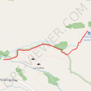
Fillmore Waterfall
Hike to the Fillmore Waterfall via the Fillmore Trail in the Organ Mountains-Desert Peaks National Monument. #Hike #Fall #Nature #Mountain
- Distance: 1.7 Km
- Elevation gain: 151 m
- Maximum elevation: 1,795 m
- Elevation loss: 2 m
- Minimum elevation: 1,644 m
- Moving time: 24 m 35 s
- Moving speed: 4.2 Km/h
- Maximum speed: 5.1 Km/h
- Total time: 26 m 6 s
- Global speed: 3.9 Km/h
- Date: 18/02/24
Interactive map
GPS track profile
About this GPS track
Name: Fillmore Waterfall GPS track, route, trail
Start: Fillmore Trail, Doña Ana County, New Mexico, United States (32.33505 -106.59952)
End: Fillmore Trail, Doña Ana County, New Mexico, United States (32.33908 -106.58550)
Coordinates: 32.33505 -106.59952 32.33908 -106.58550