Vikjord-Brustranda
- Distance: 16.8 Km
- Elevation gain: 992 m
- Maximum elevation: 529 m
- Elevation loss: 994 m
- Minimum elevation: 5 m
- Moving time: 4 h 26 m
- Moving speed: 3.8 Km/h
- Maximum speed: 10.1 Km/h
- Total time: 5 h 46 m
- Global speed: 2.9 Km/h
- Date: 23/06/14
Interactive map
GPS track profile
About this GPS track
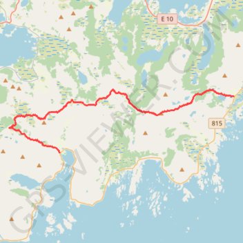
Name: Vikjord-Brustranda GPS track, route, trail
Start: 2358, Valbergsveien, Vikjorda, Vestvågøy, Nordland, 8357, Norvège (68.22718 14.07671)
End: 828, Valbergsveien, Skettenbogen, Vestvågøy, Nordland, 8357, Norvège (68.20364 13.88065)
Coordinates: 68.20364 13.82398 68.23001 14.07683
Other GPS tracks
Click on a GPS track to view route, its statistics and profile.
Stage 1: Arctic Ocean to Väylä — European Divide Trail
Distance: 2,785.0 Km • Elevation gain: 23,823 m • Maximum elevation: 722 m
Dalstinden
Distance: 6.0 Km • Elevation gain: 464 m • Maximum elevation: 439 m