Mount Hotham - Mount Bogong
Interactive map
GPS track profile
About this GPS track
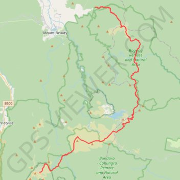
Name: Mount Hotham - Mount Bogong GPS track, route, trail
End: Mountain Creek Track, Tawonga, Alpine Shire, Victoria, Australia (-36.70000 147.25225)
Coordinates: -36.97515 147.13756 -36.69934 147.34599
Other GPS tracks
Click on a GPS track to view route, its statistics and profile.
Mount Beauty - Pyramid Hill - Bright
Australia > Victoria > Mount Beauty
#MTB
Distance: 47.8 Km • Elevation gain: 1,714 m • Maximum elevation: 1,373 m