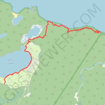
Bruce Peninsula National Park, Lake Huron, Cyprus Lake
Afternoon Hike
- Distance: 9.9 Km
- Elevation gain: 137 m
- Maximum elevation: 196 m
- Elevation loss: 136 m
- Minimum elevation: 174 m
- Moving time: 2 h 24 m
- Moving speed: 4.1 Km/h
- Maximum speed: 13.9 Km/h
- Total time: 3 h 37 m
- Global speed: 2.7 Km/h
- Date: 22/04/24
Interactive map
GPS track profile
About this GPS track
Name: Bruce Peninsula National Park, Lake Huron, Cyprus Lake GPS track, route, trail
Coordinates: 45.22668 -81.53236 45.24206 -81.49832
Other GPS tracks
Click on a GPS track to view route, its statistics and profile.
Bruce Peninsula National Park
Canada > Ontario > Bruce County
Lake Huron. #Hike #Loop #Huron #BrucePeninsula
Distance: 5.9 Km • Elevation gain: 66 m • Maximum elevation: 197 m