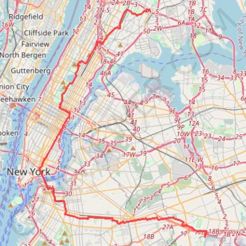
Traversée New York
Vélo. En aller simple. #Vélo
- Distance: 43.1 Km
- Elevation gain: 378 m
- Maximum elevation: 43 m
- Elevation loss: 372 m
- Minimum elevation: 0 m
Interactive map
GPS track profile
About this GPS track
Name: Traversée New York GPS track, route, trail
Start: Lefferts Boulevard, Queens County, New York, 11420, États-Unis d'Amérique (40.66190 -73.82404)
Coordinates: 40.66177 -73.99473 40.83988 -73.82225
Other GPS tracks
Click on a GPS track to view route, its statistics and profile.
New
United States > New York > New York County > New York
Distance: 88.5 Km • Elevation gain: 1,435 m • Maximum elevation: 63 m
Central Park Evening walk
United States > New York > New York County > New York
Distance: 3.8 Km • Elevation gain: 69 m • Maximum elevation: 49 m
Morning Run
United States > New York > New York County > New York
Distance: 13.7 Km • Elevation gain: 158 m • Maximum elevation: 34 m
Montréal - New York
Canada > Québec > Agglomération de Montréal > Montréal
Distance: 637.3 Km • Elevation gain: 4,134 m • Maximum elevation: 301 m
Boucle a partir de Houston Station
États-Unis d'Amérique > New York > New York County > New York
Distance: 5.5 Km • Elevation gain: 81 m • Maximum elevation: 41 m