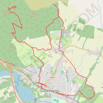
EMTB Gravel: Pitlochry Highlights - Loop
- Distance: 16.3 Km
- Elevation gain: 559 m
- Maximum elevation: 449 m
- Elevation loss: 556 m
- Minimum elevation: 98 m
- Moving time: 2 h 11 s
- Moving speed: 8.1 Km/h
- Maximum speed: 34.3 Km/h
- Total time: 2 h 29 m
- Global speed: 6.5 Km/h
- Date: 17/04/24
Interactive map
GPS track profile
About this GPS track
Name: EMTB Gravel: Pitlochry Highlights - Loop GPS track, route, trail
Coordinates: 56.69957 -3.75402 56.72643 -3.70977
Other GPS tracks
Click on a GPS track to view route, its statistics and profile.
EMTB Gravel: Loch a' Choire loop
United Kingdom > Scotland > Perth and Kinross > Moulin > Balnakeilly
To Loch a' Choire beneath Ben Vrackie #UK #Perthshire #Pitlochry
Distance: 6.7 Km • Elevation gain: 310 m • Maximum elevation: 534 m