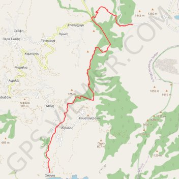
Les gorges d'Agria Irini
Randonnée pédestre. En aller simple. #Randonnée
- Distance: 18.7 Km
- Elevation gain: 1,096 m
- Maximum elevation: 1,085 m
- Elevation loss: 2,168 m
- Minimum elevation: 9 m
- Moving time: 4 h 39 m
- Moving speed: 4.0 Km/h
- Maximum speed: 25.8 Km/h
- Total time: 5 h 12 m
- Global speed: 3.6 Km/h
- Date: 18/07/12
Interactive map
GPS track profile
About this GPS track
Name: Les gorges d'Agria Irini GPS track, route, trail
Coordinates: 35.25072 23.80860 35.33482 23.86271
Other GPS tracks
Click on a GPS track to view route, its statistics and profile.
De Sougia à Profitis Ilias
Grèce > Région Crète > Περιφερειακή Ενότητα Χανίων > Soúgia
Randonnée en aller-retour depuis Sougia. #Randonnée
Distance: 15.7 Km • Elevation gain: 961 m • Maximum elevation: 363 m