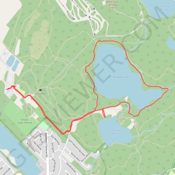
Boucle dans le Parc national du Mont-Saint-Bruno
Randonnée en boucle par le Chemin Saint-Gabriel, le Lac Seigneurial et le Lac du Moulin. #Randonnée #Boucle #Parc #Nature #Forêt #Lac
- Distance: 7.5 Km
- Elevation gain: 101 m
- Maximum elevation: 113 m
- Elevation loss: 103 m
- Minimum elevation: 50 m
- Moving time: 1 h 47 m
- Moving speed: 4.2 Km/h
- Maximum speed: 39.3 Km/h
- Total time: 2 h 21 m
- Global speed: 3.2 Km/h
- Date: 24/02/24
Interactive map
GPS track profile
About this GPS track
Name: Boucle dans le Parc national du Mont-Saint-Bruno GPS track, route, trail
Coordinates: 45.54040 -73.34374 45.55165 -73.31600
Other GPS tracks
Click on a GPS track to view route, its statistics and profile.
Montréal - Lanoraie
Canada > Quebec > Urban agglomeration of Montreal > Montreal
Saint Lawrence River. #Bike #Montréal #Lanoraie #SaintLawrence
Distance: 70.1 Km • Elevation gain: 181 m • Maximum elevation: 52 m
Pierreville - Leclercville
Canada > Quebec > Urban agglomeration of Montreal > Montreal
#Bike #Pierreville #Leclercville #Atlantic
Distance: 120.8 Km • Elevation gain: 324 m • Maximum elevation: 36 m