TRAIL 12km
- Distance: 11.7 Km
- Elevation gain: 781 m
- Maximum elevation: 614 m
- Elevation loss: 687 m
- Minimum elevation: 233 m
Interactive map
GPS track profile
About this GPS track
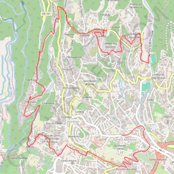
Name: TRAIL 12km GPS track, route, trail
Coordinates: 32.65910 -16.95651 32.68210 -16.93515
Other GPS tracks
Click on a GPS track to view route, its statistics and profile.
Passeio aniversario nsr
Route created on plotaroute.com
Distance: 59.3 Km • Elevation gain: 3,095 m • Maximum elevation: 1,089 m