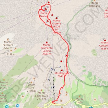
Randonnée sur l'Etna
- Distance: 11.0 Km
- Elevation gain: 408 m
- Maximum elevation: 3,283 m
- Elevation loss: 1,440 m
- Minimum elevation: 1,890 m
Interactive map
GPS track profile
About this GPS track
Name: Randonnée sur l'Etna GPS track, route, trail
Start: Sentiero ai Crateri Barbagallo, Zafferana Etnea, Catane, Sicile, 95030, Italie (37.73819 15.00078)
End: Via Giovanni Carbonaro, Nicolosi Nord, Nicolosi, Catane, Sicile, 95030, Italie (37.69943 15.00083)
Coordinates: 37.69942 14.98931 37.75340 15.01025
Other GPS tracks
Click on a GPS track to view route, its statistics and profile.
Vers les sommets de l'Etna
Italie > Sicile > Catane > Zafferana Etnea
Randonnée pédestre. En aller simple. #Randonnée
Distance: 7.0 Km • Elevation gain: 161 m • Maximum elevation: 2,923 m
2018-05-13 12:23:22
Italie > Sicile > Catane > Nicolosi > Nicolosi Nord
En boucle. #Boucle
Distance: 2.2 Km • Elevation gain: 120 m • Maximum elevation: 2,003 m