Visit of Fort William
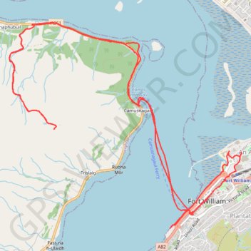
Walk in the city center, ferry to Camusnagaul and hike to Treslaig Tower Viewpoint. #Hike #Walk #City #Boat #Sea #Nature #Mountain #Forest #Highlands
- Distance: 15.5 Km
- Elevation gain: 345 m
- Maximum elevation: 284 m
- Elevation loss: 344 m
- Minimum elevation: 0 m
- Moving time: 4 h 3 m
- Moving speed: 3.8 Km/h
- Maximum speed: 14.2 Km/h
- Total time: 6 h 15 m
- Global speed: 2.5 Km/h
- Date: 12/02/24
Interactive map
GPS track profile
About this GPS track
Name: Visit of Fort William GPS track, route, trail
Start: A82, An Aird, Fort William, Highland, Scotland, PH33 6QP, United Kingdom (56.81586 -5.11620)
Coordinates: 56.81498 -5.14823 56.83624 -5.10441
Other GPS tracks
Click on a GPS track to view route, its statistics and profile.
Great Glen Way (Fort William to Fort Augustus)
United Kingdom > Scotland > Highland > Fort William
Distance: 52.6 Km • Elevation gain: 598 m • Maximum elevation: 108 m